Tag Archives: portland

Condensation Analysis for Historic Window Replacements

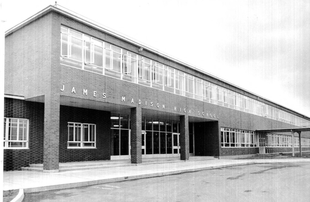
Window alterations for original single pane glass or new insulated glazing units with new interior storm windows, are growing requests from building owners of historic commercial properties. Two items we recommend to consider regarding these types of alterations: the potential for condensation as a result of the alterations, and the required review processes that may be triggered by exterior alterations to the historic building. In addition, installing a mock-up of proposed window alterations provides the opportunity to accurately measure and document existing and proposed conditions, and review the location of sealant joints and proposed glass types in order to accurately simulate the risk of condensation.

CONDENSATION ANALYSIS
Installation of new storm windows typically reduces the potential for condensation at the interior face of the glass as the surface is kept warmer. However, interior storms can lead to condensation within the interstitial space between the existing window and the new storm window. The condensation is a result of the warm humid air inside the building leaking into the colder interstitial space. As air leaks into the interstitial space, it cools and it can condense on the interior surface of the exterior glazing unit. Moisture/condensation within the interstitial space can cause deterioration of the wood surfaces and obscure views to the exterior.

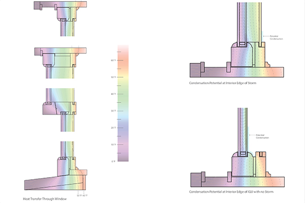
For this type of condensation analysis, PMA uses THERM, a tool for modeling 2-dimensional heat transfer and WINDOW, a tool for calculating window performance to analyze the windows. The purpose is to understand how the addition of storm windows will impact heat transfer and window performance in order to gauge the potential for condensation. The focus of this type of simulation is determining if the temperature of the air within the interstitial space would reach its dewpoint – indicating water would condense. Following the analysis results, PMA provides recommendations for mitigating and minimizing condensation based on the condensation simulations.
condensation-analysis-historic-window-replacement
LIMITATIONS
It should be noted that no single tool exists for modeling all of the variables associated with moisture and heat transfer through windows. Hygrothermal analysis (transfer of heat and moisture), is typically limited to 1-dimensional simulation which is inadequate for the complexities of a window which has wood, air, glass, sealant, etc. The 2-dimensional software that has been verified is not currently capable of simulating the complexities associated with heat transfer/soar heat gain through glass surfaces and air. The software we use for window analysis studies is designed to provide the following information:

U-Values
Solar Heat Gain Coefficient (SHGC)
Condensation Resistance Index
Surface Temperature Map of the Entire Window
2-Dimensional Heat Transfer

Additionally, the potential for condensation is directly related to air temperature and relative humidity. Depending on the use of the commercial building, the interior air temperature and relative humidity are expected to vary greatly. The simulations performed as part of this study cannot account for all of the potential temperature/relative humidity variations that may occur. The results may vary depending on different interior/exterior conditions.
condensation-analysis-historic-window-replacement
MODEL SET UP
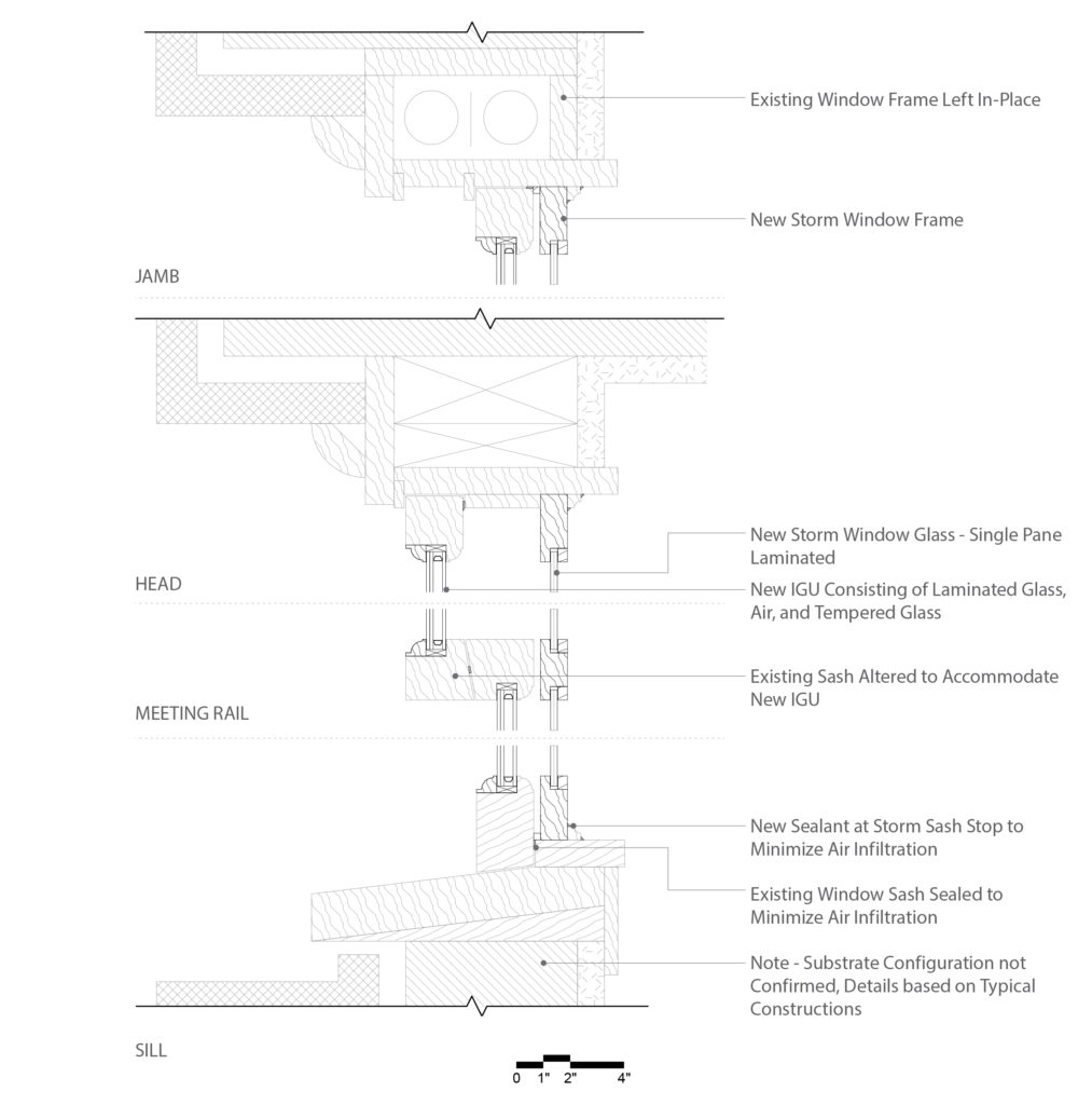
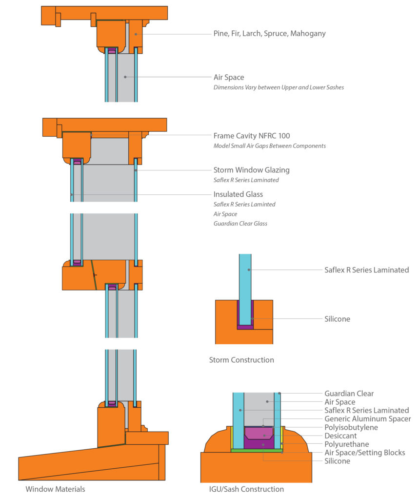
For this type of analysis we develop cross-section drawings for the window head, sill, upper jamb, lower jamb, and meeting rail. The sections are developed based on field measurements (note, sometimes we only have access to interior measurements, making exterior ones approximate). The sections are imported into THERM and modeled to simulate heat flow through the window. We then select glazing systems from the extensive glass library. The systems are selected to match the properties of the proposed materials as closely as possible.

Simulations are set up to run according to the National Fenestration Rating Council (NFRC) standards which specify conditions for simulating the interior and exterior environments. The required exterior temperature is at 0 °F and the interior at 70 °F. These temperatures provide information on more severe conditions than Portland, Oregon, however, they can be used to conservatively predict when condensation is possible. Once the cross sections has been modeled and simulated in THERM, the results are imported into WINDOW to calculate the full window performance, including SHGC, Condensation Resistance Index, U-Value, and temperature Map.
condensation-analysis-historic-window-replacement
CONCLUSION
While simulations cannot definitively predict the location and quantity of condensation, the results can be interpreted to predict the probability of condensation occurring. Sometimes our analysis shows the possibility that water will condense within the interstitial space, which happens primarily for the following reasons:

The air temperature within the interstitial space is significantly colder than the room air temperature. Any water within air infiltrating into this space may condense under the right conditions. This is exacerbated by the fact that the room temperature and relative humidity may vary greatly and cannot be strictly controlled.

The simulation for predicting condensation on the interior face of the IGU indicated that condensation was possible when the air within the interstitial space matched the properties of the interior air. Under actual conditions, the air within the interstitial space will likely be cooler and more humid than the interior air. The cooler, wetter air will have an even greater potential for condensation.

Condensation within the interstitial space between an existing and storm window is common and several methods are available to reduce the potential for condensation and mitigate any water within the cavity. For clients we provide recommendations with our analysis of window alterations for original single pane glass.

Written by Halla Hoffer, AIA, Assoc. DBIA

Laurelhurst Neighborhood-NRHP-Listing-Instagram-Post

Laurelhurst Neighborhood Historic District

Laurelhurst is a 442-acre residential neighborhood in Portland, Oregon, located thirty-two city blocks east of the Willamette River. Most of the neighborhood is in northeast Portland, with only the southernmost quarter, below E Burnside Street, in southeast Portland. César E Chávez Boulevard, originally called NE 39th Street, runs north to south, dividing the neighborhood into two halves. César E Chávez Boulevard intersects with NE Glisan Street at Coe Circle at the center of the neighborhood, forming a large roundabout. Main entrances to Laurelhurst, characterized by their historic sandstone gates, are located in four locations; two on Glisan east of 32nd, two on SE Cesar E Chavez Boulevard north of Stark, two on Burnside east of 32nd, and one at Peerless Place south of Sandy.

The historic district nomination for Laurelhurst is supportable under the “Historic Residential Suburbs in the United States, 1830-1960” Multiple Property Documentation (MPD) Form. PMA recommended that the criteria used to nominate the district include both A, for the district’s significance in the planning and development of Portland and possibly for its influence outside of Portland , and C, for the collection of architectural resources in the district. The district fits within the definition and context of a planned Streetcar Suburb, and illustrates the planning principles of the City Beautiful movement. The Laurelhurst Historic District was listed March 18, 2019, on the National Register of Historic Places.

The History of PPS McDaniel (formerly Madison) High School

At the end of January, PMA was invited to give a presentation to students at Portland Public Schools McDaniel (formerly Madison) High School. “The History of Madison High School” turned out to be engaging for many of the students in two back-to-back social studies classes taught by Mr. Jason Miller, and fun for the presenter from PMA (Kristen Minor) as well. PMA is part of the multi-disciplinary team for the PPS McDaniel High School Modernization project.

Below are highlights from the presentation illustrating changes over time in the vicinity of the school, an area that is quite familiar to the students. Old photographs of a place remind us how radically our environment changes, even though it feels (especially to a high school student) that change is s-l-o-w. The presentation also covered basic facts about the school, including its design in the International Style, a subset of Modernism, and what that means in comparison to pre-war “traditional” architectural styles. Madison was constructed in 1957 and designed by the firm of Stanton Bowles Maguire & Church, who also designed Marshall High School in SE Portland a few years later in 1960.
PPS-Madison-HS-PMAPDX-Lecture
PRE-SETTLEMENT HISTORY
Much of East Portland, especially the northerly portions along the Columbia, was Chinook tribal territory. These peoples were decimated by diseases from contacts with European and American exploration, colonialization and fur trappers in the period between the 1780s and the 1850s. Oregon Trail pioneers began to come to the area to settle by the early 1840s. The Donation Land claim act of 1850 divided the western territories into quarter mile grid sections and deeded the land to individuals (up to 320 acres) and couples (up to 640 acres), as long as you would live on and farm the land. That’s why the distribution of land by the federal government is clearly visible in the grid pattern of streets of our western cities, with anomalies like Sandy Boulevard and Foster usually being remnants of older tribal pathways.

TRANSPORTATION
This image shows 82nd Avenue where it crosses Halsey in 1916, when the train tracks crossed the roadway at grade. This location is a little more than half a mile south of the school. In 1916, people were getting around by horse and carriage, streetcar, train, walking, bicycling, and for a lucky few, driving (Model T’s went on the market in 1908). By the mid-1920s most families were able to purchase a car, but people didn’t take them everywhere like they do today.

PPS-Madison-HS-PMAPDX-Lecture

– Transportation –


LAND USE
These three photos, all looking north on 82nd Ave, are from the early 1930s. The lower right photo illustrates the 1934 construction of a viaduct for the train line, so 82nd could finally extend over the train lines. The upper photo shows early development along a segment of 82nd in the Montavilla area, with mostly houses visible along the roadway in 1932. By 1937, Portland re-zoned the entire 82nd corridor to be commercial or industrial, so all of these houses were later demolished or heavily altered. Finally, the lower left photo shows 82nd being widened in 1934, with the Madison school site at the left at the very top of the hill on the horizon. Large areas of land were still completely rural, either undeveloped or producing crops. By the 1920s and 1930s, most of the farms that had once been in this area (many originally owned by Japanese immigrant farmers around Montavilla) had given way to increased development.
PPS-Madison-HS-PMAPDX-Lecture

– Land Use –


HOUSING BOOM
The same Halsey Street intersection in 1947 is shown at the center of the photo, with 82nd Avenue stretching almost up to the Madison school site (just off the upper right of the image). None of the major freeways had been constructed yet, so the gully still only carried long-distance train tracks. After the war, housing development really took off, which resulted in an immediate need for schools in the area.
PPS-Madison-HS-PMAPDX-Lecture

– Housing Boom –


SCHOOL DESIGN AND EFFICIENCY
From 1945 to 1970, Portland Public Schools constructed 51 new schools! The district had to be efficient and smart about costs under all the pressure to create schools in such a short period of time. Modernism as a style, with its emphasis on functionality, repetition, and horizontality, worked well for the district to ensure that they could construct the most building area for the least cost. Schools were designed in standardized materials and in expandable forms, allowing maximum flexibility.
PPS-Madison-HS-PMAPDX-Lecture

– School Design and Efficiency –


As McDaniel High School moves closer to its construction start date for the PPS Modernization project, it is worth remembering that the school is a highly intact example of the mid-century International Style design aesthetic, but that the new iteration of the school will preserve portions of this design. Students in the updated school will hopefully have an appreciation for both the changes and the past design, with a glimpse into the history of change at the school and in the area surrounding the school.


Written by Kristen Minor, Associate / Preservation Planner

pmapdx-halprin-sequence-001

Halprin Sequence Concrete Conservation

The Keller and Lovejoy Fountains are part of the Halprin Open Space Sequence, designed by Lawrence Halprin and Associates, and constructed between 1963-1970. PMA provided historic materials conservation services to Portland Parks & Recreation for the current Open Space Sequence restoration project. Conservation for repair work included:

  • A limited assessment of the concrete at the Keller and Lovejoy Fountains.
  • Concrete restoration specifications for concrete flatwork and concrete fountains.
  • Assistance during construction to determine the best methods for matching new work to the historic concrete.

  • Exterior observations were performed from the ground and accessible portions of the fountains. Concrete cores were taken from each fountain in order to perform petrographic analysis of the materials. The purpose of the assessment was to provide PP&R with an understanding of the general condition of the concrete and provide repair recommendations/priorities to maintain and prolong the lifespan of the materials. For additional information on the history of the Open Space Sequence, please visit the Halprin Conservancy.

    Five Questions with Halla Hoffer, AIA, Assoc. DBIA

    This fall, Halla Hoffer, AIA, Assoc. DBIA and Peter Meijer, AIA, NCARB, had the opportunity to teach a course in the Historic Preservation Program at the University of Oregon, School of Architecture & Allied Arts: Field Recording Methods. The course is designed for students to learn and practice the methods and strategies for conducting physical site, structure, building, and object investigation using professional practice standards. The case study for learning these methods and strategies included the Belluschi designed Robert and Charles Wilson Homes situated along the Deschutes River. The homes are included in Restore Oregon’s 2019 Most Endangered Places list.
    belluschi-wilson-homes
    1. How does your architect’s mindset influence your role teaching a historic preservation class?

    Historic Preservation and Architecture are very closely tied together – and yet there can be a disconnect between the two fields. As architects, we are taught to think creatively about problems and develop design solutions, while also understanding building constructions and materials. I believe our background in architecture gives us a unique perspective on not only on the construction of historic buildings but also allows us to creatively find ways to preserve those structures. In this course, we’ve been able to share our architectural experience through discussions on building observations/assessment, drawing conventions, building materials, and more.

    2. What is your favorite aspect of working with students interested in learning about how to conduct site-specific observation/assessments for historic structures?

    We’ve had the opportunity to take two field trips out to the Wilson Homes in Warm Springs, Oregon. Each visit has been a really fun experience for the entire class. When learning how to conduct a building assessment – there is only so much information that can be communicated through a lecture. The experience of being in the field and observing a structure in person cannot compare to photographs. I’ve had a lot of fun looking at the Wilson Homes with the class – and making observations with them about the condition of the homes, original constructions/materials, existing conditions, etc.

    3. Do you have a favorite aspect of the Belluschi designed Wilson Homes? [layout; relation to the land; opportunity for rehab; etc…]

    One of the most unique aspects of the Wilson Homes is their location on the Deschutes River. The homes are located directly on the river – and deeply connected to the landscape. It is difficult to explain the experience of being within a canyon along the Deschutes River and within one of the Wilson Homes. The views and sounds of the landscape are completely intertwined with the experience of the Homes.

    4. Why is it important to rehabilitate these structures? What stories will be lost if they disappear?

    Few intact examples of northwest mid-century modern homes remain. As a culture – our preferences for interior finishes, appliances, spatial layouts, etc have changed over the last half-century. Many mid-century homes have retained their exterior appearance, yet significant interior alterations have altered the original design intent. The Wilson Homes are unique in that minimal interior renovations have taken place. In both homes, the original spatial arrangements remain in-tact and many of the finishes are unaltered. The Robert Wilson home is particularly unique in that the original kitchen remains, dishwasher included. A rehabilitation would preserve these unique examples of mid-century architecture in the Pacific Northwest.

    5. If you could give one piece of advice to graduate students (or recent graduates), what would it be?

    Take the time to form relationships with both professors and people outside of school you can learn from. School is a wonderful, structured way to gain knowledge. But… that structure falls away once you graduate – and the need to continue learning doesn’t. Having people you can reach out to for guidance can be a valuable tool!
    historic-belluschi-wilson-homes


    Halla Hoffer, AIA, Assoc. DBIA
    Associate / Peter Meijer Architect, PC

    Halla is passionate about rehabilitating historic and existing architecture by integrating the latest energy technologies to maintain the structures inherent sustainability. Halla joined PMA in 2012 and was promoted to Associate in 2016. She is a specialist in energy and environmental management, as well as building science performance for civic, educational, and residential resources. Halla meets the Secretary of the Interior’s Historic Preservation Professional Qualification Standards (36 CFR Part 61).

    pioneer-courthouse-portland

    Pioneer Courthouse Seismic and Historic Renovation

    As the second oldest federal building on the west coast and the third highest ranked historic structure in the General Service Administration’s portfolio, Pioneer Courthouse is a significant historic sandstone structure. Peter Meijer Architect, PC (PMA) acted as the Preservation Conservator hired directly by the General Service Administration to consult the construction team engaged in the base isolation seismic upgrade and historic renovation of the circa 1875 Pioneer Courthouse. PMA revised the means and methods associated with the preservation specifications, represented the Owner, and provided CA services on issues affecting the historic property.

    AWARDS & RECOGNITION
    Preservation in Action Award Pinnacle Award
    Architectural Heritage Center/Bosco-Milligan Foundation, 2008

    Craftsmanship Award
    AIA Portland Chapter, 2006

    Top Project
    Daily Journal of Commerce (DJC Oregon), 2005

    pmapdx-laurelhurst-neighborhood-RLS

    Laurelhurst Neighborhood RLS

    In spring of 2018, PMA completed a Reconnaissance Level Survey (RLS) of the Laurelhurst neighborhood in Portland, Oregon. Over 1,800 properties were surveyed. Data from the survey was used to prepare a historic district nomination of the neighborhood. A great deal of research was necessary to understand Laurelhurst’s general historical context prior to beginning survey fieldwork involved in the RLS. We began by reviewing all previous documentation that has been collected of the neighborhood—including historic tax and permit records, Sanborn maps and other graphic data, articles from historic newspapers and periodicals, and the City of Portland’s Historic Resource Inventory. We also reviewed context statements that had been written for earlier historic district nomination efforts, and primary source documents that had recorded Laurelhurst during its early stages of development.

    Founded in 1909-1910 on what had been William Ladd’s Hazel Fern Farm, Laurelhurst was developed to be a combination of pastoral English “garden suburbs” close to the city, with a more formal Beaux-Arts radial layout. An eclectic variety of architectural styles, from “fairyland” bungalows to quaint English cottages to the more classic Dutch Colonials, was chosen as a set of prototype designs for the creation of this Streetcar-era, community-centered neighborhood. To this day, most of these homes still exist and create a pleasing variation of historic styles predominantly from the 1910s to the 1930s along the pedestrian-friendly public streets and sidewalks.

    DOWNLOADS: Architectural Styles | Architects and Builders

    studio-building-pmapdx-004

    Studio Building Window Replacement

    PMA provided planning and building science services for TMT Development’s project at the Studio Building in downtown Portland. The Studio Building is a twentieth century Baroque-style building built in 1927 by Ellison-White Conservatory and designed by locally renowned architect Luther Lee Dougan. Over time, the Studio Building has undergone multiple changes including new openings (1940), the addition of a new marquee (1956), and the construction of a new front entrance (2002) to name a few.

    PMA lead the project teams Type III Design Review application for the replacement of windows on the building. After assessing the existing 192 historic steel windows, we recommended replacement windows to match the historic windows in style and size, and to fit within the existing window openings on all elevations. Drawings created during the assessment were used as part of the Type III Design Review application, as part of the pre-hearing review packet, and as part of the power-point presentation during the hearing in front of the Design Commission.

    Residential Architectural Styles in the Laurelhurst Neighborhood

    PMA is surveying and documenting the Laurelhurst neighborhood for a current project. Below is an overview of the typical residential architectural styles found throughout the neighborhood, with a brief introduction on its development.

    Laurelhurst is a 442-acre residential neighborhood in Portland, Oregon, located thirty-two city blocks east of the Willamette River. Most of the neighborhood is in northeast Portland, with only the southernmost quarter, below E Burnside Street, in southeast Portland. César E Chávez Boulevard, originally called NE 39th Street, runs north to south, dividing the neighborhood into two halves. The original 1909/10 plat boundaries of the Laurelhurst neighborhood were generally bounded by NE 32nd and 44th Avenues, and NE Halsey and SE Stark Streets. Construction of the Banfield Freeway (I-84) has had a major impact on the northern portion of the neighborhood, separating the northeastern corner of the original plat from the rest of Laurelhurst.
    Historic-Photo-Laurelhurst-PDX-Glisan-Street
    DEVELOPMENT
    The development of the neighborhood was a result of the extension of city streetcar lines to the east side of the river, enabling a tremendous population increase in this area right before 1909. The layout and development of the Laurelhurst neighborhood was strongly influenced by the national City Beautiful movement. This social movement was initially a crusade for reforms in many facets of public and private life, pushing for food and water systems, schools, and cities to be more healthful and science-based in the period after the Industrial Revolution.

    The neighborhood demonstrates the results of Portland’s early transit system that triggered the city’s expansion and enabled family life to be removed from the center of the city yet efficiently connected to the downtown hub of business and commerce. In this sense it was a true suburb, representing an idealized plan for residential living. The curvilinear streets were laid out with an eye for beauty as well as harmony between the structures and the environment. Laurelhurst remains one of Portland’s oldest intact East Side neighborhoods, and illustrates an era of tremendous suburban growth in Portland’s history, made possible by streetcar networks.

    Economic Trends 1900 – 1970
    The Lewis & Clark Exposition, in 1905, marked the beginning of a period of prosperity and growth for Portland. Portland’s population almost doubled in the single five-year period from 1905-1910, from 110,929 to 207,214 residents.[1] Laurelhurst’s population continued to increase until the onset of the Great Depression in 1929, when homebuying and development reached a low once again until just after 1940. This mirrored the trend across the United States during the Depression years, with a 95% drop in new home construction from 1925 to 1933. The 1940’s marked a period of major economic development, mainly due to advancements in the automobile industry. As a result of the Federal Aid Highway Act of 1921, the rising popularity of cars in the 1930’s, and the post-WWII recovery from the Great Depression, residents of Portland could live much further away from their jobs than they could even with the development of streetcars only thirty years prior. Suburban development and lifestyles became even more appealing. Portland experienced another period of economic decline during the Vietnam War from 1955 to 1975. In particular, property values in Laurelhurst plummeted in the 1970’s, to below average at best, and often below the cost of affordable low-income housing in the city.
    Laurelhurst-1937-Sandy-Blvd
    ARCHITECTURE
    Building restrictions maintained Laurelhurst’s reputation as a desirable neighborhood. The homes encompassed a controlled variety of architectural styles, so much so that a brochure was given to families upon purchasing a lot for the types of styles that were recommended for development. Recommended styles in Murphy’s promotional materials of the time included “Pure Italian, Japanese, Old English, Swiss Chalet, Colonial, New England, or Spanish Mission.”[2] This variety of architectural styles contributed to Laurelhurst’s reputation as a “neighborhood of character”; this aesthetic holds true as the majority of styles and examples in Laurelhurst retain their material and stylistic integrity.

    A single block, located in the southeastern quadrant of the neighborhood between SE Ash and E Burnside, was developed by the Laurelhurst Company as a showcase for bungalows.[3] This block was named Fernhaven Court, called “bungalow fairyland,” and still has many of its original features today. Some of these 1915-1925 Fernhaven Court bungalows have a noticeable Japanese design influence. The block also has a twenty-foot alleyway through the middle, one of only two alleys in Laurelhurst.

    In the southwestern quadrant, the west end of the block bounded by NE Couch, NE Davis, NE Laurelhurst Place, and NE Cesar E. Chavez Blvd was designed as “The Laurelhurst Group of Cottages,” nine homes laid out and designed by architects Ellis Lawrence and W.M. Holford with George Otten, landscape designer. Five of these were built by 1919, with a “central garden” divided by shrubs and specifying “service uses” screened by lattice. The homes, constructed by the Laurelhurst Company, are in English Cottage style.

    Paul Murphy’s own house at 3574 E. Burnside, also designed by Lawrence & Holford, received accolades for its “picturesque” design in the July 1919 issue of “The House Beautiful.” By November of that year the house was named one of the ten best examples of architecture in Portland by that same publication.[4]
    Laurelhurst-Architectural-Styles-PMAPDX-001
    Typical Neighborhood Architectural Styles
    A majority (88%) of resources in Laurelhurst date between 1910 and 1932, and the architectural styles of the neighborhood reflect that majority; the first property owners of Laurelhurst were restricted in their choices for designs, which aimed to create a cohesive and more desirable neighborhood appearance. The most prevalent architectural styles identified in Laurelhurst are Craftsman (42%), Colonial Revival (36%), and English Cottage (19%). Some houses do have a combination of styles so percentages will add up to more than 100% of resources. Other identified styles from that era include Prairie School, Tudor Revival, Mediterranean Revival, Neo-Classical; later architectural styles observed within Laurelhurst include Minimal Traditional, World War II-Era Cottage, and Ranch.
    Laurelhurst-Architectural-Styles-PMAPDX-002
    Prevalent Building Use and Typology
    Across the United States from the 1890s into the 1920s as the ideal suburban home was being refined and developed, houses were becoming more technologically innovative and less formal in layout. Two principal house typologies emerged during this period, the bungalow and the American Foursquare. Both of these were often mass-produced and offered for sale by catalog. Bungalows offered an affordable house type for a family without servants. The typical bungalow is one or one-and-a-half stories, with a broad, shallowly-pitched roof and a wide open front porch across the full front or most of the front of the house. While bungalows can be in English Cottage or Mission Revival styles, they are most often associated with the Craftsman style and the California Arts and Crafts movement. A typical Foursquare is boxy and more vertical in form, usually two to two-and-a-half stories in height. A single-height porch runs across most or all of the front of the house, and the layout is generally four major rooms on each level. Like bungalows, Foursquare houses can appear in a variety of styles.[5] The Colonial Revival style predominates in some areas, but in the Pacific Northwest the Craftsman Foursquare is by far the most prevalent style.

    After WWI, the trend for single-family homes across the U. S. was generally smaller. A variety of period revival styles appeared in the 1920s as bungalows or period cottages. Most common were the English Cottage or English Tudor as well as Colonial revival styles ranging from Dutch, English, French, and Spanish. A period cottage is generally no more than one-and-a-half story, and has a small street–fronting façade but may extend back on its lot to create a long, narrow footprint.

    Written by Kristen Minor / Associate, Preservation Planner with Marion Rosas / Designer

    Download Laurelhurst Architectural Styles.

    Footnotes
    1. K. Zisman et al, Portland Oregon’s Eastside Historic and Architectural Resources, 1850-1938 (United States Department of the Interior, 1988, as amended 2012, edited by Timothy Askin and Ernestina Fuenmayor), E:10.
    2. “Laurelhurst and its Park,” 22.
    3. A bungalow can be described as a small house, low and broad in form, with a wide front porch and spreading eaves. They are most often Craftsman in style.
    4. Rene Marshall, “In Portland, Oregon,” The House Beautiful vol 46, July 1919, 30-31 and Helen Eastham, “Best Examples of Architecture in Portland, Oregon,” The House Beautiful vol. 46, Nov 1919, 308-310, 336.
    5. McClelland et al, 56.

    Surveying the Laurelhurst Neighborhood in Portland, OR

    Founded in 1912 on the original plat of William Ladd’s Hazel Fern Farm, Laurelhurst was developed to be an example of the potential for European “garden suburbs” close to the city. An eclectic variety of architectural styles, from “fairyland” bungalows to quaint English cottages to the more classic Dutch Colonials, was chosen as a set of prototype designs for the creation of this community-centered neighborhood. To this day, many of these homes still exist, as does the pre-intended sense of comradery between its residents.
    pmapdx-laurelhurst-survey-portland-oregon
    WHAT IS THE LAURELHURST SURVEY PROJECT?
    Peter Meijer Architect, PC (PMA) is in the process of conducting a Reconnaissance Level Survey (RLS) of the Laurelhurst neighborhood in Portland, Oregon. Data from the survey will be used to prepare a potential historic district nomination of the neighborhood. A great deal of research was necessary to understand Laurelhurst’s general historical context prior to beginning survey fieldwork involved in the RLS. We began by reviewing all previous documentation that has been collected of the neighborhood—including historic tax records, Sanborn maps and other graphic data, newspaper articles from historic periodicals, and the City of Portland’s Historic Resource Inventory. We also reviewed context statements that had been written for earlier historic district nomination efforts, and primary source documents that had recorded Laurelhurst during its early stages of development.

    The primary objective of a Reconnaissance Level Survey (RLS) is to provide a “first cut” of typically residential resources within a given area that appear to meet the survey criteria for historic significance. An RLS involves only a visual evaluation of properties in relation to the overall neighborhood context, not an assessment of associated historical events or individuals connected to the property.
    pmapdx-laurelhurst-survey-portland-oregon
    With the information gathered from our preliminary research at hand, PMA set out in November 2017 to survey approximately 1800 properties that were constructed during Laurelhurst’s period of significance. Our approach will be informed by information gathered during our research and any additional background information provided by Laurelhurst residents’ initial observations. Factors includ¬ing potential eligibility, typographical distribution of resources, integrity of setting, and proximity to other resources will be considered when selecting survey properties.

    So far, we have completed 70 percent of the total survey area. As Laurelhurst consists of approximately 1,800 properties, we still have a large number of houses to go!

    There are distinct characteristics within Laurelhurst that are well known to residents and visitors. The inclusion and extent of these characteristics, like street patterns, open spaces, landscapes and trees, objects like sculpture, lamp posts, etc. will be discussed with the LNA, the City, and the State Historic Preservation Office (SHPO) to determine the importance of the characteristics in telling the story of Laurelhurst.
    pmapdx-laurelhurst-survey-portland-oregon
    SURVEY PROCESS TO DATE
    PMA project staff has been working with a taskforce of volunteers—residents of the Laurelhurst neighborhood and preservation graduate students from the University of Oregon. To date we have finished surveying three of five sections of the neighborhood. The in-field survey will be completed by late Spring 2018. Some properties have been noted as potential opportunities for an Intensive Level Survey (ILS), in which a more detailed review of the property would yield further information of its level of historic integrity and the significance of Laurelhurst as a whole. Intensive Level Surveys, if any, will also be completed by late Spring 2018. PMA aims to have a first-draft nomination ready for the Laurelhurst Neighborhood Association by June 2018.
    pmapdx-laurelhurst-survey-portland-oregon
    Challenges
    The main challenge has been the large size of the survey area, the fact that we have a limited number of staff and volunteers, and walking around all day. The weather has also been difficult at times—with very cold temperatures, rain and snowfall. Dry days at this time of the year are hard to come by, but they are ideal because many leaves have fallen from the trees that block visibility of the houses and lighting is always better on a gray day.

    Community Interaction
    Many residents of the area have already conducted their own research on the history of their houses, and many have shared with us their findings. Of the stories we have received, we learned of a cluster of houses owned by many generations of the same family, one woman who met the famous architect that designed her house, and a man who has nurtured a dilapidated house back to life. We encourage anyone who may have more information about the history of development in Laurelhurst to contact us as well.

    Interesting Resources
    We have collected a number of historic photographs of Laurelhurst homes from multiple sources, including a 1916 Brochure of “Laurelhurst and its Park”, and have had a lot of fun tracking them down. Some have been demolished, but there are still MANY that exist.
    pmapdx-laurelhurst-survey-portland-oregon

    Written By Marion Rosas / Designer